Pages

Monday, 10 October 2022

Attabad Lanslide, Hunza District, Gilgit Baltistan


Field photograph showing the front view of the Attabad Landslide. It has obstructed the main Hunza Channel causing the formation of Attabad Lake.  

I was ambitious to look at the the landslide/Rock Avalanche physically, which caused the formation of the Attabad Lake at the Hunza River, Gilgit Baltistan. I took this photograph and shared with you for your interest.  It is pertinent to mention that this slide was a hug disaster to the river and communities living there. It caused the destruction of around 26 houses and killed about 20 people in the vicinity. Moreover, it was a cause of the formation of a natural dam, and reservoir (Attabad Lake) obstructing the flow of the Hunza river near the Attabad Village. 

Wednesday, 28 October 2020

Our New Research Published about exploration of placer gold deposits through integrated geophysical and geochemical techniques

Our New Research published this month titled 

Exploring Placer Gold Deposits through Integrated Geophysical and Geochemical Techniques at the Confluence of Indus and Kabul Rivers, NW, Pakistan

Open the link to view the article!

Wednesday, 12 August 2020

Birds eye Structure in Khyber Limestone


Bird’s eye structure formed in Khyber limestone. Picture was taken during a 1 day field to the fluorite mines in Khyber agency.
Bird's Eye Structure formed in Khyber Limestone (location Khyber Dsitrict, Pakistan). PC: Owais Tayyab

Friday, 17 July 2020

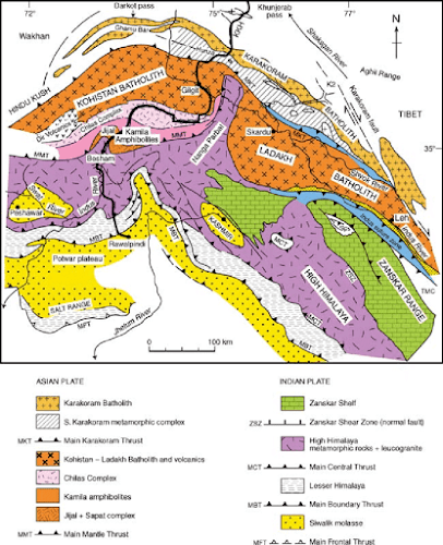
Tectonic Location of Pakistan

Pakistan is split along the boundary where Indian plate slides along the Eurasian Plate towards north along the fault zone. This fault zone is a transpressional strike slip fault called Chaman Transform Fault Zone. It starts from the south at the tripple juction of Indian, Arabian and Eurasian Plate. Towards north it crosses the Herat transform fault and meets the Pamir thrust System.  It splits the southwest part (Baluchistan area) of Pakistan. Therefore the major part of the Baluchistan Province lies on the Eurasian Plate. 


In the North some of the area of Pakistan like Hunza lies on the Karakoram Microplate, which is now considered as a part of Eurasian Plate. Some of the area of Pakistan like Kohistan, Kalam, Gilgit and Chilas lies on the Kohistan Island Arc, which is separated from the Indian Plate through the Main Mantle Thrust. The main portion of Pakistan like Punjab, Sindh and Khyber Pakhtukhwa lies on the Indian Plate. 


Sunday, 12 July 2020

Geological Appraisal of the Coal Mines in the Tanosh area, Balakot

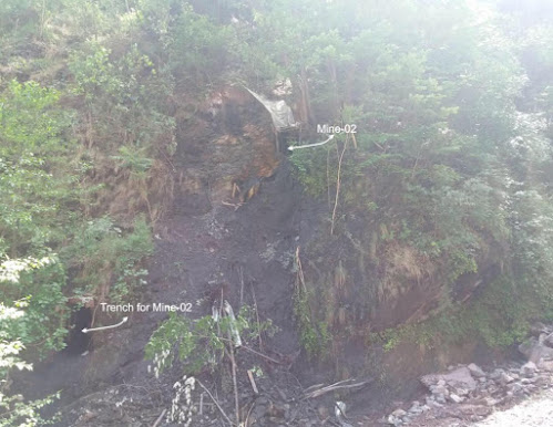
One day field trip was arranged to examine the coal mines in the area of Tanosh Nala, Balakot, Pakistan. The aim of the investigation was to evaluate the coal prospects and its economic potential. 
Balakot area is part of Sub-Himalayan Zone in northern Pakistan. It is located on the northwest tip of Hazara Kashmir Syntaxis, in footwall of Main Boundary Thrust (MBT). The rock which host the coal deposits is Hangu Formation from early Paleocene age.

North looking view of Mine-01 Quarried along the strike of Bedding in Hangu Formation. Credits: Owais Tayyab


Field photograph of trench and coal mine-02, Balakot area.


Team members from left to right: Irfan, Nowrad Ali and me


Chitarwata Formation

One day geological field to examine the Chitarwata Formation of Oligocene age. It is located on the western margin of the Indian Plate, in Sulaiman Fold and Thrust belt, NW Himalayas, Pakistan. The old name of this formation was Nari Formation. The lithology of Chitarwata formation includes sandstone, shale, claystone and limestone. 

Chitarwata Fromation of Oligocene Age. Credits: Owais Tayyab

Field to emerald mine, Swat valley, Pakistan


Emerald from Swat valley, Khyber Pakhtunkwa, Pakistan is considered as one of the best emeralds in the world. It is hosted by talc-magnesite and quartz-magnesite rocks assemblages. These emeralds deposits are considered as the one of the largest deposits of Asia. They are well known for their quality (color, transparency, and luster) in the world. The Pictures below were taken during a field to the emerald mines in Swat Valley.

A picture taken from emerald and the host rock at the emerald mine, Swat Valley. Credits: Owais Tayyab

Attabad Lanslide, Hunza District, Gilgit Baltistan

  Field photograph showing the front view of the Attabad Landslide. It has obstructed the main Hunza Channel causing the formation of Attaba...