Pages

Friday, 17 July 2020

Tectonic Location of Pakistan

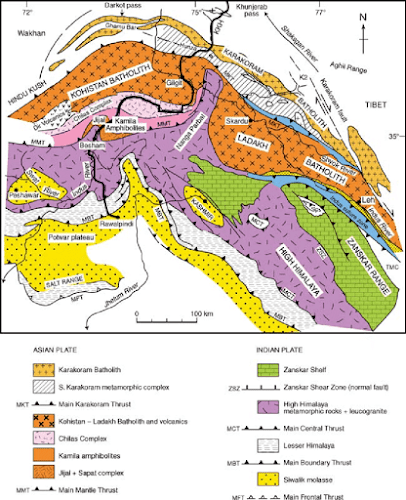
Pakistan is split along the boundary where Indian plate slides along the Eurasian Plate towards north along the fault zone. This fault zone is a transpressional strike slip fault called Chaman Transform Fault Zone. It starts from the south at the tripple juction of Indian, Arabian and Eurasian Plate. Towards north it crosses the Herat transform fault and meets the Pamir thrust System.  It splits the southwest part (Baluchistan area) of Pakistan. Therefore the major part of the Baluchistan Province lies on the Eurasian Plate. 


In the North some of the area of Pakistan like Hunza lies on the Karakoram Microplate, which is now considered as a part of Eurasian Plate. Some of the area of Pakistan like Kohistan, Kalam, Gilgit and Chilas lies on the Kohistan Island Arc, which is separated from the Indian Plate through the Main Mantle Thrust. The main portion of Pakistan like Punjab, Sindh and Khyber Pakhtukhwa lies on the Indian Plate. 


Sunday, 12 July 2020

Geological Appraisal of the Coal Mines in the Tanosh area, Balakot

One day field trip was arranged to examine the coal mines in the area of Tanosh Nala, Balakot, Pakistan. The aim of the investigation was to evaluate the coal prospects and its economic potential. 
Balakot area is part of Sub-Himalayan Zone in northern Pakistan. It is located on the northwest tip of Hazara Kashmir Syntaxis, in footwall of Main Boundary Thrust (MBT). The rock which host the coal deposits is Hangu Formation from early Paleocene age.

North looking view of Mine-01 Quarried along the strike of Bedding in Hangu Formation. Credits: Owais Tayyab


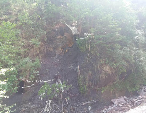
Field photograph of trench and coal mine-02, Balakot area.


Team members from left to right: Irfan, Nowrad Ali and me


Chitarwata Formation

One day geological field to examine the Chitarwata Formation of Oligocene age. It is located on the western margin of the Indian Plate, in Sulaiman Fold and Thrust belt, NW Himalayas, Pakistan. The old name of this formation was Nari Formation. The lithology of Chitarwata formation includes sandstone, shale, claystone and limestone. 

Chitarwata Fromation of Oligocene Age. Credits: Owais Tayyab

Field to emerald mine, Swat valley, Pakistan


Emerald from Swat valley, Khyber Pakhtunkwa, Pakistan is considered as one of the best emeralds in the world. It is hosted by talc-magnesite and quartz-magnesite rocks assemblages. These emeralds deposits are considered as the one of the largest deposits of Asia. They are well known for their quality (color, transparency, and luster) in the world. The Pictures below were taken during a field to the emerald mines in Swat Valley.

A picture taken from emerald and the host rock at the emerald mine, Swat Valley. Credits: Owais Tayyab

San Andreas Fault

The San Andreas Fault is a continental transform fault that runs a length of roughly 810 miles (1,300 km) through California in the United States. The fault's motion is right-lateral strike-slip (horizontal motion). It forms the tectonic boundary between the Pacific Plate and the North American Plate


Major Faults/ Thrusts In Pakistan

The collision of the Indian Plate with the Eurasian Plate occurred during late Eocene.  Kohistan Laddakh Arc (KLA) was sandwiched between the two major plates. The orogeny of Himalayan Fold belt occurred after the continuous subduction of the Indian Plate towards north beneath the Eurasian Plate. Continuous stresses developed due to the collision resulted in the development of the major thrust system. From north to south the main trusts present in Pakistan are Main Karakoram Thrust, Main Mantle thrust, Main Central Thrust(Ambiguous), Main Boundary Thrust and Main Frontal Thrust/Salt Range Thrust. 

Main Karakoram Thrust is present between Karakoram Micro plate (part of Eurasia) and KLA.  Main Mantle thrust is present between the KLA and Indian Plate, which marks the boundary of the Indian Plate. Main Central Thrust is present in India, whereas it is ambiguous in Pakistan. Main Boundary Thrust is present between the Lesser and Outer Himalayas.  Main Frontal Trust is the youngest and the southernmost thrust present in the Himalayan fold and Thrust belt. In Pakistan it is called Salt Range thrust. There is another major fault present on the Western extremity of the Sulaiman and Kirthar Fold and Thrust belts called Chaman Transform Fault. It is left lateral strike slip fault separating the Indian Plate from Eurasian plate in the northwest and western part of Pakistan.

Saturday, 11 July 2020

Ghazij Formation

This formation was observed in the remote area of Mughalkot Section in Sulaiman ranges, North-West Himalayas, Pakistan. This formation is denoted by the dominant brick red color shale with minor limestone, sandstone and claystone. It is extensively present in the eastern flank of the Sulaiman fold and belt. Maximum thickness observed in this section is up to 3000 meter. On the basis of fossil record, its age is Eocene. It forms conformable contacts with lower Dunghan Formation and upper Drug Formation.

Alternative beds of sandstone with intercalation of shale Ghazij Formation. Credits: Owais Tayyab
Alternative beds of sandstone with intercalation of shale in Ghazij Formation. Credits: Owais Tayyab


Friday, 10 July 2020

Dunghan Formation

A field was conducted to observe the rocks of Dunghan formation of Paleocene age located in the remote area of Southern Sulaiman Fold Belt, North-West Himalayas. The main purpose of the field was to collect samples and study the formation physically. Dunghan formation mainly consist of green to grey color massive bedded limestone with subordinate sandstone and shale.

Massive beds of Dunghan Formation (Paleocene). Credits: Owais Tayyab

Thursday, 9 July 2020

Geochronology

It is the branch of geology which deals with the study of finding the age of a rock body and the events associated with it. The term of Geochronology was first introduced in 1983 by H.S Williams, an American Geologist and described it as a discipline which is related to the study of time and the related geological events happening in earth history. It helps in finding the questions such as when did a geological event occurred? when did the tectonic plates collided? what is the rate of subduction or uplifting of a plate? Are the rocks of one area same in age as the rocks in the other area? Geochronology is the heart of geology. It provide a base for the interpretation of the other fields of geology in respect to the history of earth.


Attabad Lanslide, Hunza District, Gilgit Baltistan

  Field photograph showing the front view of the Attabad Landslide. It has obstructed the main Hunza Channel causing the formation of Attaba...